Over the past few years, commuting in Pune has become significantly slower compared to the past. Areas such as Wagholi, Hinjewadi, and Hadapsar have witnessed rapid development; however, the Inner Ring Road infrastructure is struggling to keep pace with the growing volume of traffic.
To address this issue, authorities are planning the ‘Pune Inner Ring Road’ project. Its objective is to provide enhanced connectivity across Pune, thereby eliminating the need for vehicles to traverse through the congested central areas of the city.
This brief guide outlines the project’s alignment, provides the latest updates, and covers other essential details.
What is Inner Ring Road Pune?
The Inner Ring Road is a major road network planned for the development of Pune and its surrounding areas. Once completed, it will interconnect various highways, industrial zones, and the rapidly expanding residential areas situated around the city.
This Inner Ring Road is expected to improve the flow of both local vehicular traffic and the heavy traffic traversing the Mumbai, Nashik, Solapur, Ahmednagar, and Bengaluru highways.
This project is distinct from the larger Pune Outer Ring Road initiative. This Inner Ring route is designed to be situated closer to the city centre, with the primary objective of streamlining the city’s daily traffic and enhancing local connectivity.
Some reports cite the length of this Inner Ring Road as 105 kilometres, whereas the broader regional ring road schemes—associated with the PMRDA and MSRDC—extend well beyond this 105-kilometre mark. The project involves multiple agencies and phases; consequently, the precise figures cited in publicly available reports may vary.
Inner Ring Road Pune Map and Route Details
The Inner Ring Road Pune map encompasses a range of cities in the process of development and connects major highways.
The planned alignment is expected to pass through or connect areas like:
- Solu
- Vadgaon Shinde
- Wagholi side
- Nagar Road corridor
- Satara Road side
- Chimbli
- Charholi
- Tulapur
- Alandi region
- Pirangut side
- Mulshi belt
- Maval region
The planned alignment is anticipated to traverse or connect zones such as:
- Solu to Vadgaon Shinde
- Vadgaon Shinde to Nagar Road
- Nagar Road to Satara Road stretches
- Town planning scheme sections under PMRDA and PMC
The concept for this plan is deflecting traffic that is a major issue on city roads, even when cars simply want to traverse Pune.
For instance, trucks or highway vehicles that travel between Nashik the other side of Nashik to Bengaluru side will not require to travel through central Pune once the Inner Ring Road has been made operational.
- Nagar Road
- Katraj stretches
- Hadapsar side
- Wakad routes
- Hinjewadi access roads
Why the Project is Important for Pune
Pune is growing rapidly. The IT park, residential developments, warehouses, and industrial zones are growing all over the city.
Due to this, a lot of outlying areas are seeing the same kind of traffic as central city areas.
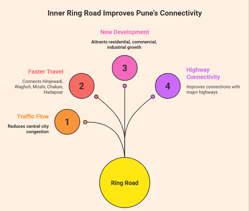
The project to build an Inner Ring Road can assist in a variety of ways:
Better Traffic Flow
Motor vehicles moving between highways could be able to avoid the central Pune roadways. This could reduce congestion within the city.
Faster Travel Between Growing Areas
Travellers who travel from Hinjewadi, Wagholi, Moshi, Chakan and Hadapsar may be able to enjoy better road connectivity in the future.
Support for New Development
Road infrastructure usually attracts:
- Residential projects
- Warehousing
- Commercial spaces
- Retail growth
- Industrial investment
Better Highway Connectivity
The project is expected to improve connections with:
- Mumbai-Bengaluru Highway
- Pune-Nashik Highway
- Pune-Solapur Highway
- Pune-Ahmednagar Highway
Inner Ring Road Pune Status Update
According to updates from the PMRDA regarding the project, proposals for land acquisition for the sections situated between Nagar Road and Satara Road have already been submitted.
Recent reports also indicate that compensation rates for certain villages have been finalized to help expedite the land acquisition process.
As of now, the project is progressing step by step. Construction work across the entire corridor has not yet been completed, the reason for which is:
- Land acquisition takes time
- Some stretches involve forest clearances
- Coordination between multiple authorities is needed
- Urban planning approvals are still ongoing in certain areas
PMRDA has also continued to make budget allocations for the Inner Ring Road project during the recent planning meetings.
Certain sections could progress more quickly than others, based on approvals and work on land transfer.
Inner Ring Road Pune Completion Date
One of the most common concerns people have is the inner circle road Pune timetable for its completion.
At present, there is no definitively confirmed date for completion of the whole project due to the fact that work is being carried out in stages.
Based on the most recent reports on infrastructure and updates on projects:
- Some areas in the west are expected to be more developed and may witness major progress by 2026-2027
- The eastern parts of the larger ones could require a longer time to complete.
- The completion of all related phases may be delayed until 2028 or later, depending on land acquisition as well as construction pace
In various reports concerning infrastructure and real estate, the years 2027 and 2028 are being discussed as the timeframe for achieving major completion targets.
However, it must be borne in mind that large-scale infrastructure projects in India frequently face delays due to issues related to approvals, compensation-related disputes, and environmental clearances.
Consequently, this timeframe may be subject to revision in the future.
Areas That May Benefit from the Project
Numerous areas that are developing in Pune are already attracting the spotlight due to the planned road connectivity.
Some areas likely to benefit include:
- Wagholi
- Charholi
- Moshi
- Chakan belt
- Pirangut side
- Hinjewadi nearby areas
- Maval region
- Nagar Road stretches
While the project is crucial but there are a few obstacles that are slowing the pace of progress.
However, buyers should still check:
- Actual road alignment
- Final approvals
- Land acquisition status
- Distance from interchanges
- Existing infrastructure nearby
before investing based only on future infrastructure news.
Challenges Facing the Inner Ring Road Project
Land Acquisition: This is the main problem in many areas. Land acquisition across villages and urban areas can take the longest time.
Environmental Approvals: Certain areas are dominated by the forest or land clearings with sensitive properties.
Coordination Between Agencies: PMC, PMRDA and other departments are involved in various sections.
Rising Costs: Large road projects get more expensive with time because of inflation and compensation adjustments.
This is the reason why it is recommended to follow a phased approach.
Frequently Asked Questions
Ques. What is the Inner Ring Road Pune Project?
Ans. The Inner Ring Road Pune Project is a major infrastructure development planned to improve traffic flow and connectivity across Pune city and nearby areas.
Ques. Which villages are covered under the Pune Inner Ring Road Project?
Ans. Several villages around Pune are expected to be connected through the project, helping improve regional transport and real estate growth.
Ques. What is the current status of the Inner Ring Road Pune Project?
Ans. The project is under different stages of planning, land acquisition, and development by the concerned authorities.
Ques. How will the Pune Inner Ring Road benefit commuters?
Ans. The road will reduce traffic congestion, shorten travel time, and provide better connectivity between major highways and suburbs.